
Parcours du Tour de France 2026 : guide complet étape par étape, profils altimétriques et cartes
Last Updated: 10:47 am CEST - Monday, 6 July 2026
Aller à la section
Voici le guide complet du parcours du Tour de France 2026, incluant les 21 étapes avec les profils altimétriques confirmés, les pourcentages des ascensions, le découpage semaine par semaine, les nouvelles ascensions, les profils des arrivées au sommet, les informations sur l'accès pour les spectateurs et les détails sur les fermetures de routes. Le tracé s'étend de Barcelone, le 4 juillet, jusqu'aux Champs-Élysées à Paris, le 26 juillet, traversant cinq massifs montagneux — les Pyrénées, le Massif central, le Jura, les Vosges et les Alpes — sur une distance totale de 3 333 km.
Carte du parcours du Tour de France 2026
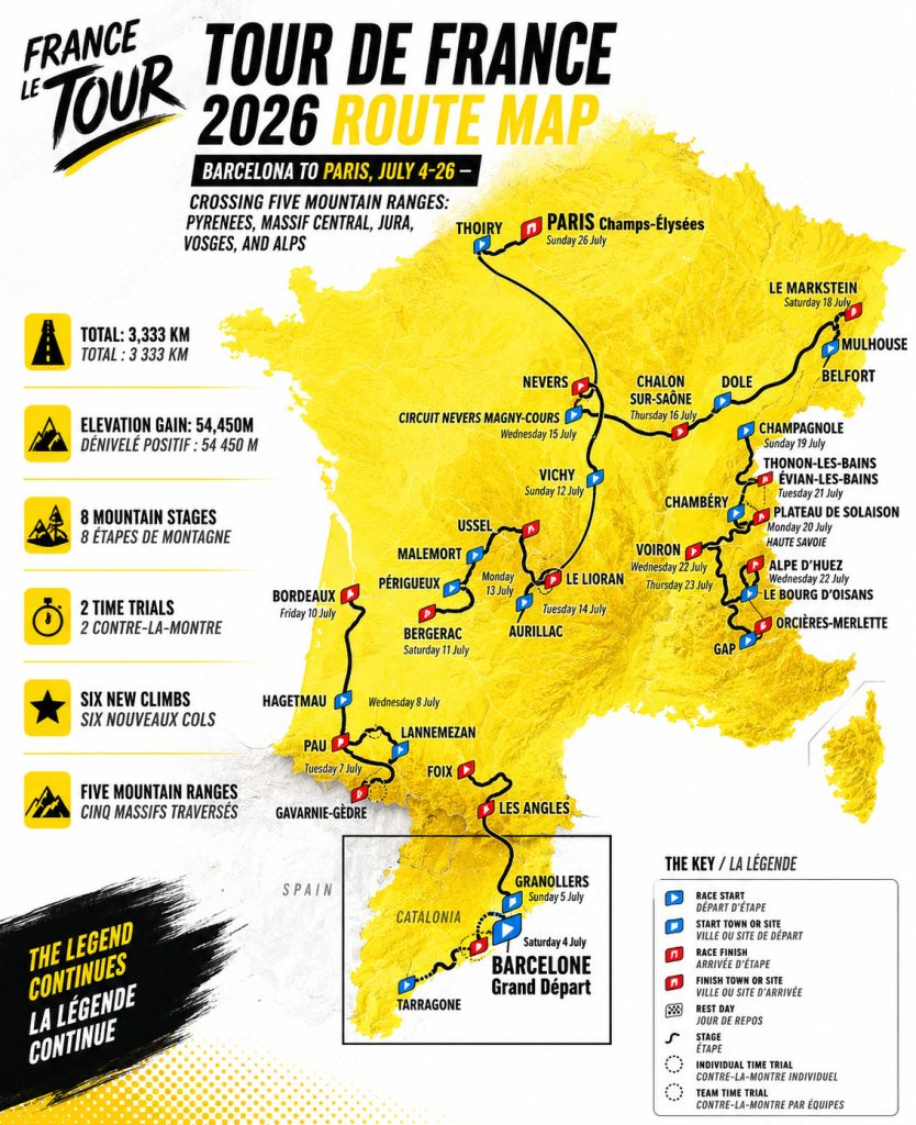
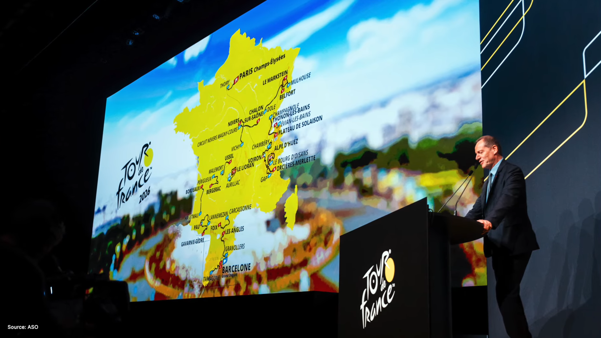
Le parcours de l'édition 2026 a été dévoilé le 23 octobre 2025 au Palais des Congrès de Paris. Le directeur de course, Christian Prudhomme, l'a présenté devant un public d'environ 3 500 personnes. Sa conception est délibérée : une première semaine d'une difficulté inédite dans l'histoire moderne du Tour, un unique contre-la-montre court placé tardivement dans la troisième semaine, et deux arrivées au sommet à l'Alpe d’Huez lors d'étapes consécutives — une configuration jamais tentée en 113 éditions de la course. Le tracé compte 30 ascensions majeures répertoriées — un total identique à celui de l'édition 2023, très appréciée —, dont 6 sont inédites sur le Tour, avec un point culminant situé au sommet du col du Galibier, à 2 642 mètres d'altitude.
En bref — Le parcours du Tour de France 2026
Résumé de l'itinéraireItinéraire global
3 333 km · 54 450 m de dénivelé positif total · 21 étapes · 7 régions françaises · 29 départements · 3 provinces catalanes · Annoncé le 23 octobre 2025.
Cinq chaînes de montagnes
Pyrénées (étapes 3 et 6) → Massif central (étapes 9 et 10) → Jura (étape 13) → Vosges (étape 14) → Alpes (étapes 15, 18, 19 et 20).
Grand Départ de Barcelone
1re étape : contre-la-montre par équipes (19,7 km) — le premier contre-la-montre par équipes inaugural depuis 1971. Les deux premières étapes se terminent à Barcelone — une première historique. La 3e étape franchit la frontière française en traversant les Pyrénées.
Six nouvelles voies d'escalade
Côte de Begues (S2), arrivée sommet Montée de Gavarnie‑Gèdre (S6), Col de la Griffoul (S10), Col du Page + Col du Haag (S14), arrivée sommet Plateau de Solaison (S15), flanc sud‑est du Col de Sarenne (S20).
Cinq arrivées au sommet
Gavarnie‑Gèdre (S6) · Le Lioran / Puy Mary (S10) · Plateau de Solaison (S15) · Orcières‑Merlette (S18) · Alpe d'Huez ×2 (S19 + S20).
Premières arrivées consécutives de l'Alpe d'Huez dans l'histoire du Grand Tour.
Point culminant
Col du Galibier, 2 642 m (étape 20). Egalement : Col du Tourmalet 2 115 m (étape 6), Col du Glandon 1 924 m (étape 19).
En bref
Itinéraire 2026Distance totale
3,333 km (2,071 mi)
Chaînes de montagnes
5 — Pyrénées, Massif central, Jura, Vosges, Alpes
Escalade totale
54 450 m de dénivelé positif
Point culminant
Col du Galibier, 2,642 m
Nombre d'étapes
21 (7 plats, 4 vallonnés, 8 de montagne)
Régions françaises
7 régions + 3 provinces catalanes
Finitions Summit
5 (incl. Alpe d’Huez ×2)
Départements
29 départements français
Nombre total d'ascensions majeures
30 ascensions classées
Itinéraire annoncé
23 octobre 2025, Paris
Aperçu du parcours du Tour de France 2026 — Régions, départements et carte
Le tracé du Tour de France 2026 a été conçu pour renouer avec l'esprit originel d'un Grand Tour : une course qui traverse physiquement la France, plutôt que de concentrer ses étapes sur une ou deux régions. Après un départ en terre étrangère, en Catalogne, le parcours balaie le Sud-Ouest en passant par les Pyrénées, traverse le plateau volcanique du Massif central, sillonne le vignoble bourguignon, gravit les sommets granitiques et boisés des Vosges, descend vers le Jura et s'achève par une semaine alpine redoutable avant le final parisien.
Le tracé de l'itinéraire — Ville par ville
Itinéraire completSemaine 1 — Espagne et Pyrénées
Jour de repos
Semaine 2 — Massif central et Jura
Jour de repos
Week 3 — Alps & Paris
Régions françaises traversées — Dans l'ordre de l'itinéraire
7 régionsCatalogne (Espagne)
Barcelone, Tarragone, Granollers — Étapes 1 à 3
Occitanie
Les Angles, Carcassonne, Foix, Lannemezan, Pau, Gavarnie — Étapes 3 à 6
Nouvelle-Aquitaine
Hagetmau, Bordeaux, Périgueux, Bergerac — Étapes 7 à 8
Auvergne-Rhône-Alpes
Ussel, Aurillac — Étapes 9 à 10 · Chambéry, Voiron, Gap, Bourg-d'Oisans, Alpe d'Huez — Étapes 17 à 20
Bourgogne-Franche-Comté
Vichy, Nevers, Dole, Champagnole — Étapes 11 à 13 et 15
Grand Est
Belfort, Mulhouse, Le Markstein — Étapes 13-14
Île-de-France
Paris, Montmartre — Étape 21
Programme complet des étapes du Tour de France 2026 — Les 21 étapes
Chaque étape a été confirmée par ASO lors de la présentation du parcours le 23 octobre 2025 et recoupée avec le guide technique de mai 2026. Les étapes de montagne clés sont mises en évidence. Consultez le programme détaillé étape par étape du Tour de France 2026.
Tour de France 2026 – Programme complet des étapes
21 StagesLe Grand Départ Barcelone — La Route de l’Espagne
Barcelone n'est que la troisième ville espagnole à accueillir un Grand Départ du Tour de France en 113 éditions. Saint-Sébastien a donné le coup d'envoi du Tour 1992, Bilbao celui de l'édition 2023 ; désormais, la capitale catalane inscrit son nom à une liste qui compte déjà Londres, Bruxelles et Copenhague. Lors de l'annonce faite en octobre 2025, le directeur de la course, Christian Prudhomme, a déclaré aux journalistes : « Barcelone est une ville de sport, une ville qui sait accueillir le monde, une ville de passion. » Le tracé du Tour de France 2026 témoigne d'une réelle ambition pour la ville : deux arrivées d'étape au Montjuïc en l'espace de deux jours.
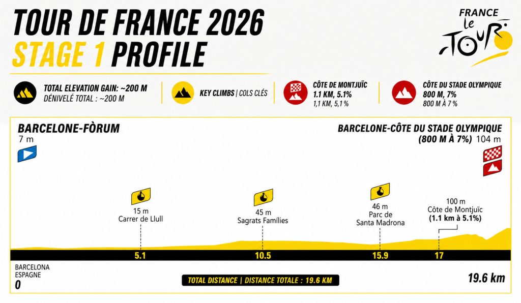
Profil de l'étape 1 — Contre-la-montre par équipes de Barcelone (4 juillet, 19,7 km)
Le parcours de 2026 débute près du front de mer de Barcelone ; la route passe ensuite devant la Sagrada Família avant de s'élever vers le complexe olympique de la colline de Montjuïc. La côte de Montjuïc (1,1 km à 5,1 %) et la côte du Stade olympique (1,1 km à 5,1 %) marquent les 4 derniers kilomètres. Fait notable, ASO applique ici le format de chronométrage individuel expérimenté lors de Paris-Nice 2023 : c'est le temps propre à chaque coureur qui est retenu à l'arrivée, et non le temps du quatrième coureur de l'équipe, comme le veut la tradition. Les équipes emmèneront leurs leaders du classement général dans les deux ascensions de Montjuïc pour un sprint *de facto*. Il s'agit du premier contre-la-montre par équipes inaugural sur le Tour depuis 1971, ainsi que de la toute première arrivée d'étape située aux abords du site des Jeux olympiques de 1992.
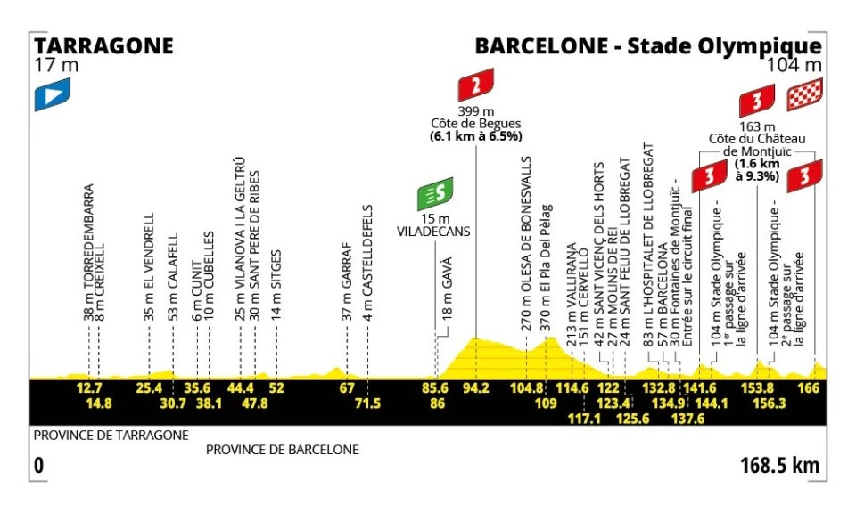
Profil de l'étape 2 — De Tarragone à Barcelone (5 juillet, 178 km)
Tarragona’s UNESCO-listed Roman amphitheatre is the backdrop for the Stage 2 startLa route côtière remonte vers le nord en passant par Sitges avant d'aborder la nouvelle côte de Begues, située au milieu de l'étape. Le moment décisif se jouera sur le circuit final de Montjuïc : la côte du château de Montjuïc (1,6 km à 9,3 %, dont un tronçon de 600 m dépassant les 7 %) s'avère nettement plus exigeante que les ascensions de la première étape. Le peloton devra parcourir ce circuit à deux reprises. Lors du Grand Départ de Bilbao en 2023, Pogačar, Vingegaard et van der Poel avaient enflammé le Tour sur un terrain moins sélectif en l'espace de 48 heures ; le circuit de Montjuïc étant plus difficile en 2026, on peut s'attendre à voir un scénario similaire se reproduire.
Profil de l'étape 3 — De Granollers aux Angles (6 juillet, 196 km, Pyrénées transfrontalières)
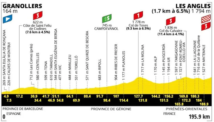
La 3e étape s'élance de Granollers et entame immédiatement l'ascension. Le col de Sant Feliu de Codines constitue une mise en jambes en douceur. La Collada de Toses (9,3 km à 6,5 %) propulse la course sur les crêtes élevées des Pré-Pyrénées. Le col du Calvaire (11,4 km à 4,1 %) franchit la frontière française à 1 836 mètres d'altitude ; il s'agit d'une montée soutenue malgré une pente moyenne modérée. Une descente roulante de 24 km mène à l'arrivée à la station de ski des Angles (1,7 km à 6,5 %). Le dénivelé positif total de cette troisième journée avoisine les 4 000 mètres. C'est ici que la course quitte définitivement l'Espagne. Tout prétendant au classement général qui ne serait pas parfaitement préparé pour ce Tour en paiera le prix fort avant même que la première étape de haute montagne ne soit officiellement au programme.
Parcours de la première semaine du Tour de France 2026 — 4–12 juillet
Espagne et Pyrénées — Étapes 1 à 9
Env. 22 000 m de dénivelé positif · Trois étapes pour sprinteurs · Étape reine pyrénéenne le 6e jour · Record de dénivelé pour une première semaine de Tour moderne
La première semaine du Tour de France 2026 est, en termes de dénivelé, la plus exigeante jamais vue en début d'épreuve dans l'histoire moderne du Tour. Au terme de la 6e étape, soit après six jours de course, les coureurs auront accumulé environ 16 200 mètres de dénivelé positif. À titre de comparaison, le Grand Départ du Pays basque en 2023 en totalisait 12 800 sur la même période. Les Pyrénées font leur apparition dès la 3e étape. À l'issue de la 6e étape, le passage au Tourmalet et une nouvelle arrivée au sommet à Gavarnie auront livré le premier verdict significatif pour le classement général. Trois étapes pour sprinteurs (5, 7 et 8) ainsi qu'une étape accidentée propice aux échappées (4) offrent aux sprinteurs des opportunités entre les séquences de haute montagne.
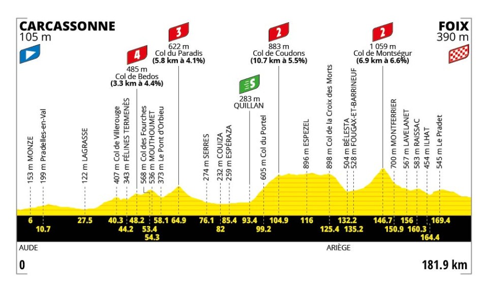
Parcours de la 4e étape — Carcassonne – Foix (7 juillet, 182 km, accidenté)
Carcassonne’s 12th-century citadel, a double-walled UNESCO World Heritage fortress with 52 towers, is the stage start backdrop. The road heads east through Cathar country into the Ariège via Col de Villerouge (8.6 km/3%), Col de Bedos (3.4 km/4.3%), Col du Paradis (6.4 km/4.1%), Col de Coudins (10.5 km/5.5%), and Col de Montségur (6.9 km/6.6%). The final climb comes 35 km from the Foix finish, a long enough run-in for a sprint or for a small group to hold off the bunch. Classic breakaway-specialist terrain: heavy roads, rolling hills, multiple climbs in the first half, and enough distance between the last summit and the finish to create tactical uncertainty.
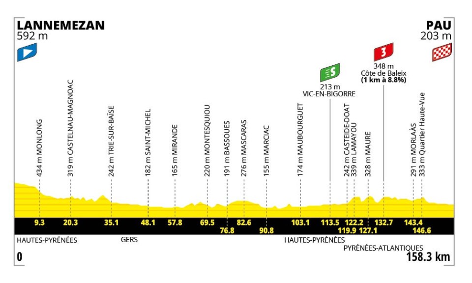
Parcours étape 5 — Lannemezan à Pau (8 juillet, 158 km, Plat)
La première véritable occasion pour les sprinteurs. Longue de 158 km, l'étape reliant Lannemezan à Pau est la plus courte de la première semaine ; elle s'achève sur un final plat à Pau, ville d'arrivée habituelle des sprints du Tour. Le parcours présente un relief vallonné en son milieu, mais rien de nature à mettre en difficulté un pur sprinteur ayant bien négocié la première partie de l'étape. Jasper Philipsen, Tim Merlier, Jonathan Milan et Olav Kooij abordent cette journée en ayant économisé un maximum d'énergie depuis la 3e étape. Il s'agit de la dernière étape de plaine avant l'étape reine dans les Pyrénées.
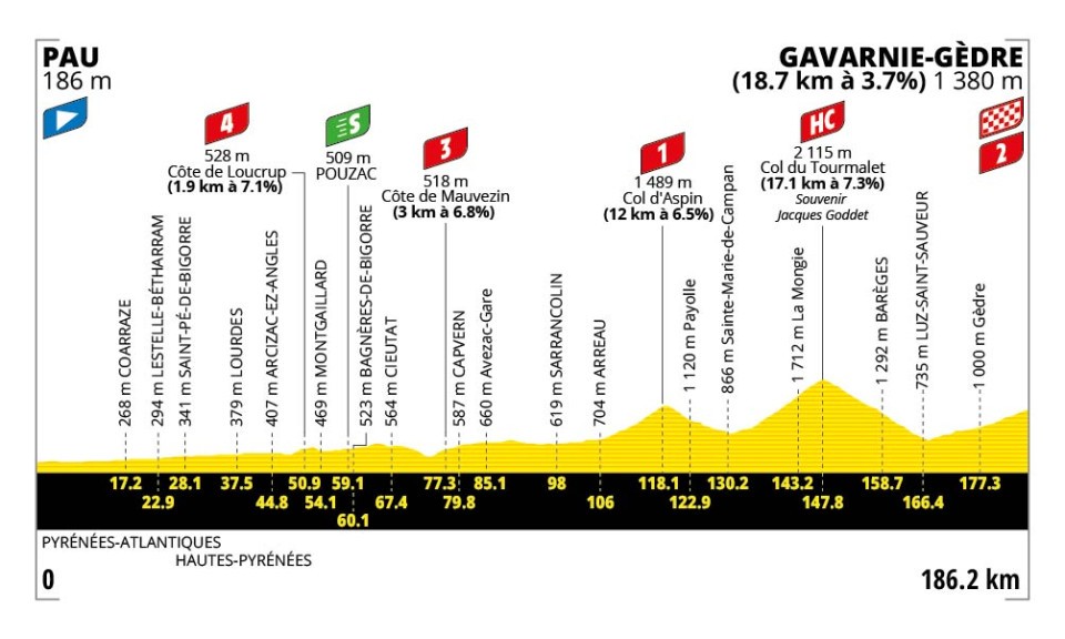
Étape 6 : Parcours et profil altimétrique — Pau – Gavarnie-Gèdre (9 juillet, 186 km) ⭐ Arrivée au sommet
La 6e étape constitue le premier grand rendez-vous pour le classement général du Tour 2026. Trois cols sont au programme des 80 derniers kilomètres. Le col d’Aspin (12 km à 6,5 %, sommet à 1 490 m) ouvre le volet montagneux. Le col du Tourmalet, via l’ascension depuis Sainte-Marie-de-Campan (17 km à 7,3 %, sommet à 2 115 m), fait sa 91e apparition sur le Tour de France — un record historique — et porte la course au-delà des 2 000 mètres d’altitude pour la première fois de l’édition 2026. Après une descente rapide, la nouvelle arrivée au sommet de Gavarnie-Gèdre s’élève sur 18,7 km avec une pente moyenne de 4 %, en remontant la vallée du Gave de Pau en direction du cirque de Gavarnie.
Le piège de Gavarnie : une pente moyenne de 4 % peut sembler abordable. Pourtant, après 4 100 mètres de dénivelé positif accumulé et alors que les jambes portent encore les stigmates de l’ascension du Tourmalet, ces 18,7 kilomètres sont tout sauf une partie de plaisir. Au sommet se dresse le cirque de Gavarnie, un amphithéâtre glaciaire classé au patrimoine mondial de l’UNESCO, dominé par une paroi rocheuse verticale de 1 400 mètres. C’est l’un des décors naturels les plus spectaculaires du sport européen. Cette étape marquera la première véritable sélection parmi les prétendants au classement général de l’édition 2026. En 2025, Evenepoel avait abandonné dans les pentes du Tourmalet ; la manière dont il affrontera ces mêmes ascensions façonnera le récit du début de la course.
Stages 7 & 8 Route — Hagetmau to Bordeaux + Périgueux to Bergerac (Flat Sprints)
Stage 7 (175 km, Hagetmau to Bordeaux) gives the sprinters their second window. Hagetmau makes its first Tour de France appearance, and the town is a Camino Francés stop. The fast run to Bordeaux through the Landes forests is a classic sprint stage. Stage 8 (182 km, Périgueux to Bergerac) crosses Dordogne country between two of the region’s most recognisable names, on the flat valley roads that suit pure bunch sprint dynamics. Two intermediate sprint points are contested on each stage in 2026, the first time since 2010, making the points classification battle more active throughout each day.
Stage 9 Route — Malemort to Ussel (July 12, 185 km, Hilly)
Week 1 closes with 3,400 metres of climbing across the Corrèze without a single flat kilometre. Malemort to Ussel through the rolling volcanic Massif Central terrain is the most consistently demanding non-mountain stage of the entire race. No single climb is a GC threat, but the accumulated fatigue of 185 km without recovery is real. This stage reveals which squads have fresh domestiques heading into Week 2 and which have been grinding all week.
Rest Day 1 — Monday, July 13, Cantal
Transfer day: teams move from Ussel to Aurillac (~90 km). Race infrastructure relocates. Press conferences throughout the day. GC teams conduct physical assessments, tactical planning, and equipment preparation. The first genuine public interrogation of whether Vingegaard’s Giro–Tour double is showing fatigue. This rest day is not recovery — it is repositioning.
TDF 2026 Week Two Route — July 14–19
Massif Central, Jura, Vosges & Alps — Stages 10–15
Approx. 18,000m climbing · Bastille Day summit · Vosges dark horse · New Alpine summit at Solaison
Week 2 builds from Bastille Day’s volcanic Massif Central summit to the pre-rest-day ambush of a new Alpine summit finish that no rider has ever contested. Three distinct terrain phases: Massif Central (Stage 10), transitional plains through the Loire Valley and Burgundy (Stages 11–13), the Vosges dark horse (Stage 14), and the Alpine opener on the new Plateau de Solaison (Stage 15). A total of approximately 18,000 metres of climbing across six stages — fewer than Week 1, but concentrated in ways that expose second-week fatigue.
Stage 10 Route & Elevation Profile — Aurillac to Le Lioran (July 14, 167 km) ⭐ Bastille Day Summit
Stage 10 falls on July 14. That date has an effect on French cycling that no other calendar date replicates — ASO deliberately sequences its most aggressive GC racing on Bastille Day, and the crowd density on Puy Mary and Pas de Peyrol transforms the race into something closer to a football final.
The route from Aurillac crosses the new Col de la Griffoul before the iconic Puy Mary (1,589m) and Pas de Peyrol before a summit finish at the Le Lioran ski station. The Massif Central character is specific: no climb reaches alpine altitude, but the volcanic terrain creates repeated short sharp ramps rather than sustained gradients. Riders who excel at threshold-level power held for 8–15 minutes tend to perform better here than those who prefer 20–25 minute sustained alpine efforts.
Stages 11 & 12 Route — Vichy to Nevers + Magny-Cours to Chalon-sur-Saône (Flat)
Stage 11 (161 km, Vichy to Nevers) runs through the Loire Valley from the thermal spa city to Nevers. The shortest flat stage of the 2026 race. Stage 12 (181 km) starts from the Circuit de Nevers Magny-Cours, one of France’s Formula 1 venues, making its Tour debut, and runs through Burgundy wine country to Chalon-sur-Saône. Open Burgundy plains carry echelon risk if south-westerly winds develop: a crosswind split on Stage 12 could produce GC time gaps without a single climb. Sprinters’ teams need to control both stages.
Stage 13 Route — Dole to Belfort (July 17, 205 km, Hilly — Longest Stage)
Stage 13 is the longest stage of the 2026 Tour at 205 km, the only stage over 200 km in an edition deliberately skewed toward shorter, more explosive racing. The Jura hills between Dole and Belfort provide multiple attack points on rolling limestone terrain without the commitment of a full mountain stage. The Lion de Belfort statue — Frédéric Auguste Bartholdi’s 11-metre sandstone lion, the monumental precursor to his Statue of Liberty design — marks the finish. GC teams should be content to ride tempo here. Breakaway specialists who build careers on 200+ km days have the perfect canvas.
Stage 14 Route & Profile — Mulhouse to Le Markstein (July 18, 155 km, Vosges)
Stage 14 is the dark horse stage of the entire 2026 Tour. The Vosges Mountains are unlike the Pyrenees or Alps in almost every measurable way: no col above 1,424m, rounded granitic summits, narrow forested roads, and climbing profiles that produce repeated 4–6 minute threshold efforts rather than 20-minute sustained grinds. Two brand-new Tour climbs, Col du Page and Col du Haag, precede the Grand Ballon (1,424m) and Le Markstein Fellering summit finish. Total climbing for the stage: 3,800m across seven ascents. Stage 14 in 2023 was where Vingegaard cracked the field and confirmed his second yellow jersey on similar Markstein terrain. The 2026 version is harder with the two new climbs added earlier in the day.
Stage 15 Route & Elevation Profile — Champagnole to Plateau de Solaison (July 19, 184 km) ⭐ NEW Summit Finish
Plateau de Solaison has never hosted a Tour de France summit finish. At 11.3 km and 9.1% average gradient, with sections pushing above 12%, it is the steepest summit finish average in the 2026 race. The climb faces north, sitting in shadow for most of the afternoon. At altitude above 1,471 metres, temperatures at the summit can fall to 10°C even in late July. Multiple Jura hills precede the final ascent, building accumulated fatigue before the decisive climb. No rider has prior Tour de France data on Solaison: no split times from previous editions, no tactical reference from team archives.
Why this stage matters beyond the climb itself: it is the last stage before Rest Day 2, positioned immediately before the only ITT. History shows that riders in difficulty always crack hardest in the final summit before a rest day. Adrenaline masking fatigue is a finite resource. Solaison will produce the clearest picture of every GC contender’s actual condition before the final week begins.
Rest Day 2 — Monday, July 20, Haute-Savoie
The most tactically loaded rest day of the 2026 Tour. Stage 16 — the only individual time trial — follows directly on July 21. Teams spend the rest day reconnoitring the Évian-to-Thonon course (26 km, Lake Geneva), selecting equipment (disc wheels, aero helmets, superbikes), and finalising TT positioning. GC riders who want to ambush rivals on the ITT begin preparation here. The tactical decisions made on July 20 will determine who gains or loses minutes on July 21.
TDF 2026 Week Three Route — July 21–26
The Alpine Finale & Paris — Stages 16–21
~16,000m climbing · Three consecutive summit finishes · Back-to-back Alpe d’Huez · Paris July 26
Week 3 opens with the race’s only individual time trial, then delivers three consecutive Alpine summit finishes — Orcières-Merlette, Alpe d’Huez (Day 1), and the Queen Stage to Alpe d’Huez (Day 2), before the Paris parade. The structure is deliberate: the ITT reshapes the GC before a single Alpine climb, then three summit finishes in three days compress the decisive moments into 72 hours. The 2026 Tour winner is determined in Week 3.
Stage 16 Route & Profile — Évian-les-Bains to Thonon-les-Bains (July 21, 26 km, Individual Time Trial)
The only individual time trial of the 2026 Tour. The 26 km course runs along the southern shore of Lake Geneva from the thermal spa resort of Évian to Thonon-les-Bains, generally flat with one rolling climb section early in the stage and a fast finale. Expected winning time: approximately 28:30 at an average speed above 54 km/h. GC riders start in reverse order from 12:30 CET.
The ITT is critically short in the context of a GC race: Pogačar’s 2025 form projects to a 40–50 second advantage over Vingegaard across 26 km. Evenepoel, the reigning Olympic ITT champion, could potentially produce the fastest GC-rider time of the day. If the GC is within 1:30 before Stage 16, the yellow jersey could change hands on the Lake Geneva shore road.
Stage 17 Route — Chambéry to Voiron (July 22, 175 km, Flat)
Transition stage. The Isère valley runs from Chambéry to Voiron, with Voiron becoming the Stage 18 start town. The sprinters’ last realistic opportunity of the 2026 Tour before three consecutive summit finishes removes their window entirely. GCN teams manage watts. Sprint trains organise for the final mass sprint of the race. The stage is flat, fast, and unambiguous — exactly what GC leaders need 24 hours after the ITT.
Stage 18 Route & Profile — Voiron to Orcières-Merlette (July 23, 185 km) ⭐ Summit Finish
Stage 18 opens the decisive Alpine trilogy. The route heads south from Voiron toward Grenoble, then climbs to Engins (11.4 km at 5.4%) and continues over a sustained false flat to Saint-Nizier-du-Moucherotte before dropping to the banks of the Drac river. After roughly 10 km in the valley at 900 metres altitude, the Col de Manse and Col du Festre precede the final steady climb to Orcières-Merlette. The ski station at 1,850m sits at altitude where oxygen debt builds quickly, the final 7.1 km at 6.7% feels considerably harder than the gradient suggests.
Orcières-Merlette’s Tour history runs deep. Luis Ocaña won here alone in 1971, having ridden solo for 60 km and finished 9 minutes ahead of Eddy Merckx. Roglic won a similar-format stage here in 2020. The 2026 edition expects one of those days: a long, attritional approach followed by a summit finish where only the strongest climbers reach the front. The race generates 3,950 metres of total climbing — the warm-up before Alpe d’Huez. Who wins Stage 18 is largely irrelevant. How the GC leaders arrive at Orcières-Merlette predicts everything about Stage 19.
Stage 19 Route & Elevation Profile — Gap to Alpe d’Huez (July 24, 128 km) ⭐ Alpe d’Huez Day 1
Stage 19 is short, savage, and explosive. The 128 km from Gap to Alpe d’Huez produces 3,605 metres of climbing across four ascents: Col Bayard (5.1 km at 7.2%), Col du Noyer (7.2 km at 8.5% — the sharpest regular pass of the race), Col d’Ornon (5.6 km at 6.2%), then the final 13.8 km at 8.1% up Alpe d’Huez itself.
The Col du Noyer at 8.5% is the hardest numbered pass before the Alpe and represents the first serious point of selection on Stage 19. Strong climbers targeting a breakaway will attack here. GC teams arriving with weakened domestiques face immediate problems on a climb where the gradient leaves no shelter. Col d’Ornon serves as the final filter, a 5.6 km climb at 6.2% after the Noyer descent that arrives just 35 km from the Alpe d’Huez base. Only those with genuine resilience stay competitive to the foot of the final climb.
Alpe d’Huez profile: 13.8 km at 8.1% average from Le Bourg-d’Oisans at approximately 720m to the summit resort at 1,860m. The 21 numbered hairpins define this year route, hairpin 21 at the bottom, hairpin 1 at the top. The first two kilometres average close to 10%. Hairpins 10 and 11 in the middle section push into double digits. Hairpin 7, Dutch Corner, is the most densely packed spectator point in cycling. Short (128 km) means the peloton arrives at the Alpe base largely together. When Tom Pidcock announced himself to the world in 2022 on this same climb, he attacked from a small group and rode solo to the summit. In 2026, with three weeks of fatigue in their legs and the Queen Stage the following morning, every GC rider will race defensively here — except the one with something to prove.
Stage 20 Route & Elevation Profile — Queen Stage to Alpe d’Huez (July 25, 171 km) ⭐⭐
Stage 20 is the definitive stage of the Tour de France 2026. Le Bourg-d’Oisans to Alpe d’Huez, 171 km, via four mountain passes: the 2026 Tour produces its final answer here.
The Four Climbs of Stage 20 — Confirmed Gradient Data Étape 20
The Col de Sarenne’s backstory: ASO first routed the Tour de France over the Sarenne descent in 2013, using it as an innovative loop to create a double Alpe d’Huez stage. A French newspaper labelled the descent ‘la descente la plus stupide du Tour moderne’, the most stupid descent in the modern Tour, due to its narrow, partially unpaved surface. ASO listened. For 2026, the south-eastern flank of the Sarenne has been resurfaced and widened specifically to enable this stage design. The result is a climb that has genuinely never been raced at this level before.
The Galibier at 2,642 metres is the highest point of the 2026 Tour. At that altitude, air pressure is approximately 74% of sea level, meaning riders generate roughly 14% less aerobic power at the same perceived effort compared to sea level, even with altitude adaptation. Summit temperature on the Galibier in late July can reach 5–8°C with wind, requiring a lightweight rain cape that riders discard before the Sarenne descent. The tactical decision of when to attack on the Galibier and whether to risk a cold descent to Sarenne with an aggressive lead will define the stage.
Stage 21 Route — Thoiry to Paris Champs-Élysées (July 26, 130 km, Sprint Finale)
The final stage covers 130 km from Thoiry to Paris. The Montmartre section, three ascents of the cobbled Rue Lepic introduced in 2025 and confirmed for permanent inclusion by Prudhomme after its ‘wildly successful’ debut, arrives 15 km from the Champs-Élysées finish. In 2025, Wout van Aert dropped Pogačar on Montmartre in one of the most dramatic final-stage attacks in recent Tour history. The Rue Lepic is 1.8 km and averages 5.5%, but the cobblestones and the 15 km of flat road between Montmartre and the finish line mean the race typically returns to a bunch sprint on the Champs-Élysées, with the GC leader managing any breakaway. The yellow jersey is not threatened on Stage 21. The sprint is. Montmartre is the moment — Paris is the confirmation.
All 5 Summit Finish Elevation Profiles — Tour de France 2026
Five summit finishes define the 2026 GC battle. Three are new to the Tour de France. Here is every summit profile with confirmed gradient data.
Summit 1: Gavarnie-Gèdre — Stage 6
NEWLongueur
18.7 km
Pente moyenne
4% avg
Altitude
~1,350 m
Stage
Stage 6, Jul 9
The low average gradient is the trap. Gavarnie-Gèdre climbs a long Pyrenean valley after the Tourmalet’s full descent, the gradient never exceeds 7% for long, but it never relents, and legs that have already climbed Aspin and the Tourmalet will feel every kilometre of those 18.7 km. The Cirque de Gavarnie — a 1,400m vertical rock amphitheatre, a UNESCO site, one of the most dramatic landscapes in Europe — forms the backdrop to a finish that is both a GC test and a sensory spectacle.
Summit 2: Le Lioran / Puy Mary — Stage 10 (Bastille Day)
BASTILLE DAYSummit Finish
Le Lioran
Puy Mary
1,589 m peak
Finish Altitude
Le Lioran ski station
Stage & Date
Stage 10, Jul 14
The Puy Mary and Pas de Peyrol are the emotional core of this stage. The Massif Central’s volcanic terrain produces a different climbing experience from the Alps or Pyrenees: no single ramp is long enough to allow sustained power advantages, but the relentless rolling demands threshold power held repeatedly. Riders who respond best to short sharp accelerations rather than 20-minute sustained efforts tend to dominate Bastille Day in the Massif Central. The French crowd on July 14 is among the loudest in cycling.
Summit 3: Plateau de Solaison — Stage 15 (NEW — Steepest Summit Finish)
NEWLongueur
11.3 km
Pente moyenne
9.1% — steepest of the race
Altitude
1,471 m
Stage & Date
Stage 15, Jul 19
Plateau de Solaison is the 2026 Tour’s wildcard summit. At 9.1% average over 11.3 km, it carries the steepest average gradient of any summit finish in the race — steeper than Alpe d’Huez (8.1%), steeper than Gavarnie (4%), steeper than Orcières-Merlette. No team has prior performance data on this climb from the Tour. Several sections exceed 12%. The north-facing aspect means the summit road sits in shadow for most of the afternoon. Temperatures at 1,471 metres drop rapidly after 16:00 even in July. Solaison is where ASO has hidden the biggest surprise of the Tour de France 2026 route.
Summit 4: Orcières-Merlette — Stage 18
STAGE 18Final Climb
7.1 km
Pente moyenne
6.7% final
Altitude
1,850 m
Stage & Date
Stage 18, Jul 23
Orcières-Merlette is steeped in Tour history. In 1971, Luis Ocaña attacked on this finish after riding solo for 60 kilometres, finishing 9 minutes ahead of Eddy Merckx. In 2020, Primoz Roglic won on Stage 4 as the race began. In 2026, the stage structure stair-steps through the Isère valley via Col de Manse and Col du Festre before the steady 7.1 km final ramp. At 1,850 metres altitude, the oxygen deficit builds quickly on the final climb regardless of gradient. Stage 18 opens the Alpine trilogy. How GC leaders arrive here determines the tactics of Stages 19 and 20.
Summit 5: Alpe d’Huez — Stages 19 & 20 (First Back-to-Back in Tour History)
BACK-TO-BACKClassic Ascent
13.8 km
Pente moyenne
8.1%
Sommet
1,860 m
Stages & Dates
S19 (Jul 24) + S20 (Jul 25)
Alpe d’Huez is 13.8 km at 8.1% from Le Bourg-d’Oisans to the summit resort. The 21 numbered hairpins are each named after a Tour de France winner, from Fausto Coppi at hairpin 21 to a blank awaiting the 2026 champion at hairpin 1. The first two kilometres average close to 10%. Hairpins 10 and 11 push into double digits. The Dutch Corner at hairpin 7 is typically the densest crowd point in professional cycling — tens of thousands of fans camped on the mountainside for days, the road barely wide enough for the riders to pass.
Stage 19 uses the classic approach: Col Bayard, Col du Noyer, Col d’Ornon, then the full 13.8 km Alpe ascent. Stage 20 attacks from a completely different direction — Col de la Croix de Fer, Col du Télégraphe, Col du Galibier, Col de Sarenne, then the final 3.8 km section at 6.1% onto the Alpe d’Huez resort road. Two consecutive days finishing on the same mountain for the first time in Tour de France history.
All Major Climbs — Confirmed Elevation Data
Every significant categorised climb confirmed from ASO official 2026 route descriptions, profile data, and stage files. New climbs highlighted.
Confirmed Key Climbs & Elevation Data
All Stages| Monté | Stage | Longueur | Avg % | Sommet | Status / Context |
|---|---|---|---|---|---|
| Côte de Begues NEW | 2 | — | — | — | Mid-stage Tarragona→Barcelona. |
| Collada de Toses | 3 | 9.3 km | 6.5% | — | Cross-border climb from Spain into France. |
| Col du Calvaire | 3 | 14.9 km | 4.1% | 1,836 m | Cross-border pass to Les Angles. Longest climb of Stage 3. |
| Col de Coudins | 4 | 10.5 km | 5.5% | — | Penultimate climb, Stage 4. Cathar country. |
| Col de Montségur | 4 | 6.9 km | 6.6% | — | Final climb, Stage 4, 35km from Foix finish. |
| Col d’Aspin | 6 | 12 km | 6.5% | 1,490 m | 74th Tour appearance. Pyrenean classic. Stage 6 opener. |
| Col du Tourmalet (via Campan) | 6 | 17 km | 7.3% | 2,115 m | 91st Tour appearance — most in Tour history. Via Sainte-Marie-de-Campan. |
| Montée de Gavarnie-Gèdre NEW | 6 | 18.7 km | 4% | ~1,350 m | NEW summit finish. UNESCO Cirque de Gavarnie backdrop. |
| Col de la Griffoul NEW | 10 | — | — | — | Stage 10 approach to Puy Mary. |
| Puy Mary / Pas de Peyrol | 10 | — | — | 1,589 m | Massif Central summit. Bastille Day stage centrepiece. |
| Col du Page NEW | 14 | — | — | — | Vosges Stage 14. |
| Col du Haag NEW | 14 | — | — | — | Vosges Stage 14. |
| Grand Ballon | 14 | — | — | 1,424 m | Highest Vosges summit. Familiar Tour climb. |
| Plateau de Solaison NEW | 15 | 11.3 km | 9.1% | 1,471 m | NEW summit finish. Steepest avg of race. North-facing, cold. |
| Col du Manse | 18 | — | — | — | Stage 18 approach to Orcières. Cat 1. |
| Col du Festre | 18 | — | — | — | Stage 18 penultimate climb before Orcières. |
| Orcières-Merlette (final climb) | 18 | 7.1 km | 6.7% | 1,850 m | Altitude finish. Ocaña legend (1971). Roglic won here 2020. |
| Col Bayard | 19 | 5.1 km | 7.2% | — | Stage 19 opener. Breakaway platform. |
| Col du Noyer | 19 | 7.2 km | 8.5% | — | Sharpest regular pass of Stage 19. First major GC selection point. |
| Col d’Ornon | 19 | 5.6 km | 6.2% | — | Penultimate climb, Stage 19. 35km from Alpe d’Huez base. |
| Alpe d’Huez — Classic Ascent | 19+20 | 13.8 km | 8.1% | 1,860 m | 21 hairpins. First ×2 consecutive in Grand Tour history. Dutch Corner at hairpin 7. |
| Col de la Croix de Fer | 20 | 24 km | 5.2% | 2,067 m | Queen Stage opener. Long grinding approach. |
| Col du Télégraphe | 20 | 11.9 km | 7.1% | 1,566 m | Flows directly onto Galibier with minimal descent. |
| Col du Galibier — Roof of 2026 | 20 | 17.7 km | 6.9% | 2,642 m ⭐ | Highest point of 2026 Tour. 74% air pressure. Final km above 9%. |
| Col de Sarenne — SE flank (NEW direction) NEW | 20 | 12.9 km | 7.3% | — | Specifically repaved by ASO for 2026. Summit 15km from Alpe d’Huez finish. |
| Alpe d’Huez — Sarenne finale | 20 | 3.8 km | 6.1% | 1,860 m | Post-Sarenne final section. Total Stage 20: 5,601m climbing. |
Five Mountain Ranges — TOUR DE FRANCE 2026 Route Guide by Range
Tour de France 2026 is the first edition in recent years to cross all five major French mountain ranges. Each range has a distinct character that demands different physical and tactical responses from riders.
The Pyrenees — Week 1 Route (Stages 3 & 6)
The Pyrenees appear twice. Stage 3 crosses the eastern range via the Collada de Toses and Col du Calvaire — relatively accessible, high-altitude passes that introduce Pyrenean climbing on day three. Stage 6 is the full Central Pyrenees experience: Aspin, Tourmalet, and the new Gavarnie summit over 186 km. Pyrenean climbing character: sustained high-altitude ascents above 1,800m, exposed ridgeline passes with strong winds, and long climbs from relatively low bases. The Tourmalet’s eastern Sainte-Marie-de-Campan approach (17 km at 7.3%) is considered harder than the western Barèges approach by most climbers; the gradient is sustained rather than variable.
The Massif Central — Week 1/2 Route (Stages 9 & 10)
The ancient volcanic plateau of the Massif Central dominates Stages 9 and 10. No col reaches alpine altitude; the Puy Mary tops at 1,589m, but the terrain never allows recovery. Stage 9’s 3,400m of climbing without a flat kilometre is a textbook Massif Central day. Stage 10’s Bastille Day summit at Le Lioran arrives via the Puy Mary volcanic landscape. Massif Central character: repeated short, sharp efforts at 4–8 minute power rather than sustained 20-minute alpine grinds. The volcanic rock creates a distinctive riding surface and the landscape is dramatically different from the more familiar Tour mountain settings.
The Jura — Week 2 Route (Stage 13)
Stage 13’s 205 km from Dole to Belfort crosses the Jura limestone plateau, the longest stage of the race and the best breakaway terrain. The Jura character is rolling rather than mountainous: no single col stands out as a GC threat, but the accumulated fatigue of 205 km on undulating terrain is genuine. The Lion de Belfort statue at the finish, Bartholdi’s sandstone lion, predecessor to the Statue of Liberty, is one of the most striking stage finishes in the Tour de France 2026 route.
The Vosges — Week 2 Route (Stage 14)
The Vosges Mountains are the Tour’s dark horse terrain. Rounded granitic summits, narrow forested roads, and climbing profiles that top out below 1,424m define Stage 14. Col du Page and Col du Haag are new to the Tour route. Grand Ballon and Le Markstein are familiar returns. Vosges character: repeated sub-5-minute explosive efforts rather than sustained gradient. Puncheurs and riders with explosive 4–6 minute power output perform disproportionately well here compared to their general Alpine performances. Stage 14 is the 2026 Tour’s hidden selection stage; its difficulty is underrated by the average gradient and summit altitude.
The Alps — Week 2/3 Route (Stages 15, 18, 19, 20)
The Alps deliver the 2026 Tour’s most decisive four stages. Stage 15’s Plateau de Solaison opens the Alpine block, a new summit finish at 9.1% average, the steepest in the race. Stage 18 approaches from the Isère valley via Col de Manse and Col du Festre to Orcières-Merlette. Stage 19 delivers Alpe d’Huez for the first time via Col Bayard, Col du Noyer, and Col d’Ornon. Stage 20, the Queen Stage, crosses the Croix de Fer, Télégraphe, Galibier, and Sarenne before a second consecutive Alpe d’Huez summit. Alpine character: extreme altitude (Galibier at 2,642m), sustained 15–25 minute efforts, technical high-speed descents, and weather conditions that can change from 30°C at valley level to 5°C at the Galibier summit within a single stage.
Spectators’ Route Guide — Road Closures & Access
Watching the Tour de France costs nothing. There are no tickets for roadside viewing, no barriers between spectators and riders. It is one of the last great free sporting spectacles on earth, and the 2026 edition provides exceptional in-person opportunities at both the Barcelona Grand Départ and the historic Alpe d’Huez double finish.
When Will the Riders Pass Through Your Area?
The peloton’s passing time can be calculated with reasonable accuracy from the stage rollout time and the average speed for the terrain. Use this guide:
- Flat road at full race speed: approximately 42–46 km/h average. A stage starting at 12:30 CET covers 42 km in roughly 60 minutes.
- Mountain ascent: approximately 20–22 km/h on a Cat 1 or HC climb. The Tourmalet at 17 km takes roughly 50 minutes from the foot of the climb.
- Mountain descent: 65–80+ km/h on open descents. The Galibier to Sarenne descent covers 30 km in approximately 25 minutes.
- To find the official passing time for your specific town: search ‘Tour de France 2026 horaire passage [your town name]’ on Google. Local mairies and tourist offices publish confirmed passing times 4–6 weeks before the race.
Road Closure Rules — What You Need to Know
Tour de France roads are closed to all motorised traffic (cars, motorcycles, campervans) but remain open to cyclists and pedestrians throughout. Key rules:
- Mountain passes (Tourmalet, Alpe d’Huez, Galibier): typically close 24–48 hours before the stage for the most popular ascents. Early arrival is essential. The Alpe d’Huez road closes the afternoon before for both Stages 19 and 20, no vehicles above Le Bourg-d’Oisans after approximately 17:00 on July 23 and July 24.
- Flat stage routes: roads close the morning of the stage, typically 4–6 hours before the peloton passes. Local police manage junctions and crossings.
- You can cycle the TDF route on the day of the race, right up until the Tour caravan (approximately 2 hours before riders) approaches your position — the gendarmerie will direct you off the road at that point.
- Parking: approach roads close first. Arrive early and park outside the closure zone, then cycle or walk the final distance.
Best Viewing Spots on the 2026 Route
Spectator GuideThe most famous spectator point in cycling. Tens of thousands of Dutch fans camp here for days. The road disappears under people. Riders pass within arm’s reach at the point where the stage is typically decided.
91st Tour appearance — the most celebrated climb in cycling history. The Campan approach gives early access before the road closes. Riders are visible for the full final hour of climbing.
The TTT launch is the most accessible Grand Départ format — teams launch every 2–4 minutes and you can see every squad. Stage 2 circuit provides multiple viewing opportunities on the same lap.
The most emotionally charged stage of the race. French national holiday + Massif Central volcanic landscape + summit finish. Arrive July 13 (rest day) to secure a good position.
The cobbled Rue Lepic in a holiday atmosphere — Paris bistros open, crowds lining the street. Three ascents in the final 15 km before the Champs-Élysées. Free access from anywhere in Montmartre.
Can You Ride the 2026 Tour de France Route Yourself?
L’Étape du Tour de France 2026 gives amateur cyclists the chance to ride Stage 20, Bourg-d’Oisans to Alpe d’Huez via the Croix de Fer, Télégraphe, Galibier, and Sarenne, covering 170 km and 5,400 metres of climbing. The event is limited to approximately 16,000 riders and takes place on closed roads several weeks before the Tour. Registration at letapedutourdefrance.com. For those who want to ride the route informally. The Alpe d’Huez, Tourmalet, and Galibier are all publicly accessible climbs year-round when weather permits.
Is Your City on the Tour de France 2026 Route?
The full city list above covers every stage start and finish town. For towns between stages, search your commune name + ‘Tour de France 2026 horaire passage’ on your local mairie (town hall) website, local authorities publish confirmed peloton passing times 4–6 weeks before the race.
What the 2026 Route Means for the General Classification
The architecture of the Tour de France 2026 route was designed to favour a complete rider, one who can team time trial, resist on short ITTs, and excel on explosive summit finishes. Pure rouleurs cannot win this Tour: 26 km of time trial is too short to recover minutes lost in the mountains. Pure climbers face the same problem: five summit finishes over three weeks is not enough to overcome a 30-second TTT deficit from a strong squad, and the Vosges stage will punish those without explosive short-power capacity.
Why the Route Favours Pogačar — and Where Vingegaard Can Win
Tadej Pogačar’s profile aligns with this route in every significant dimension. The TTT opener plays to UAE Team Emirates-XRG’s collective strength; they have not lost a WorldTour team time trial in over 18 months heading into this race. The short ITT removes the scenario where Vingegaard opens a 3-minute gap on flat ground. Five summit finishes give Pogačar repeated opportunities to take bonus seconds at stages others concede. The Vosges stage suits his explosive short-power capacity. Nothing about the 2026 route is designed to disadvantage him.
Vingegaard’s path to yellow: win Stage 6 (Tourmalet-Gavarnie), limit ITT losses to under 45 seconds, and deliver a Stage 20 Galibier-Sarenne-Alpe performance that decisively exceeds Pogačar. That is possible. The Giro-Tour double is the primary risk variable; five weeks between the Rome finale and the Barcelona start is short for recovery and peak re-preparation, but Vingegaard’s training team have been building his fitness specifically for this timeline since December.
The Evenepoel Equation
Remco Evenepoel’s route to Tour victory requires four simultaneous conditions: limit TTT deficit to under 35 seconds, limit Stage 6 Tourmalet losses to under 1 minute, win Stage 16’s ITT outright, and then produce Stage 20 climbing that matches either Pogačar or Vingegaard. The ITT advantage is the clearest pathway. If Evenepoel wins Stage 16 and the GC is within 90 seconds going into the Alpine finale, the 2026 Tour is genuinely three-way unpredictable. He would be the first Belgian to wear yellow since Lucien Van Impe in 1976.
Route Records Set in 2026
- Highest opening week climbing total in modern Tour history: ~16,200m by the end of Stage 6 (previous record: ~12,800m in 2023 Basque Grand Départ edition)
- First back-to-back summit finishes on the same mountain in Tour de France or Grand Tour history: Alpe d’Huez, Stages 19 + 20
- First stage-1 team time trial since 1971: Stage 1 Barcelona
- Col de Sarenne was used in new (south-eastern) direction for the first time in a professional race
- Six new climbs in a single edition — the highest count since 2019, according to ASO route analysis
Tour de France Femmes 2026 Route
The Tour de France Femmes avec Zwift 2026 runs August 1–9, starting in Switzerland and finishing in Nice after 9 stages. The decisive stage is Stage 7 on August 7, a summit finish on Mont Ventoux via the Bedoin approach.
Route Overview — Tour de France Femmes 2026
Dates: August 1–9, 2026. Start: Switzerland. Finish: Nice (August 9). Stage 4: individual time trial into Dijon (21 km). Stage 7 (August 7): Mont Ventoux summit finish via Bedoin — 16 km at 8.8% average, climbing to 1,912 metres. This is the first time Ventoux has appeared in the Tour de France Femmes. The Bedoin approach is the hardest of the three possible Ventoux routes, gaining 1,650 metres from bottom to summit.
Broadcasters: Peacock (USA), SBS On Demand (Australia), TNT Sports/Discovery+ (UK), France TV (France) — same rights holders as the men’s race in most markets. The same Peacock subscription covering the men’s Tour runs through the women’s finale on August 9.
Tour de France 2026 Route – Frequently Asked Questions
Tour de France 2026 Route — FAQs
Route FAQTour de France 2026 starts in Barcelona on July 4 with a 19.7km team time trial and finishes on the Champs-Élysées in Paris on July 26. The route covers 3,333 km across 21 stages, passing through five mountain ranges — the Pyrenees, Massif Central, Jura, Vosges, and Alps — across seven French regions and three Catalan provinces. Key finishes include Gavarnie-Gèdre (Stage 6), Le Lioran/Puy Mary (Stage 10), Plateau de Solaison (Stage 15), Orcières-Merlette (Stage 18), and Alpe d’Huez on consecutive days (Stages 19 and 20).
Tour de France 2026 crosses five mountain ranges in route order: the Pyrenees (Stages 3 and 6), the Massif Central (Stages 9 and 10), the Jura (Stage 13), the Vosges (Stage 14), and the Alps (Stages 15, 18, 19, and 20). It is the first edition to include all five major French mountain ranges since 2023.
The Col du Galibier at 2,642 metres is the highest point of the Tour de France 2026 route, reached in Stage 20 (the Queen Stage) on July 25. The Galibier is climbed via the Col du Télégraphe approach at 17.7km and an average gradient of 6.9%. The final kilometres exceed 9% as the road rises above the snowline.
Six climbs appear for the first time: Côte de Begues (Stage 2), Montée de Gavarnie-Gèdre as a summit finish (Stage 6), Col de la Griffoul (Stage 10), Col du Page and Col du Haag (Stage 14), Plateau de Solaison as a summit finish (Stage 15), and the Col de Sarenne via its south-eastern flank (Stage 20), which ASO specifically repaved for this edition.
The classic Alpe d’Huez ascent is 13.8km at 8.1%, climbing from ~720m to 1,860m. 21 hairpins (21 at bottom, 1 at top). First two km ~10%. Hairpins 10–11 enter double digits.
Stage 19 (July 24) reaches Alpe d’Huez via Bayard, Noyer, and Ornon, then the classic 21-hairpin ascent. Stage 20 (July 25) takes a different route: Croix de Fer, Télégraphe, Galibier, and Sarenne before the final 3.8km Alpe section. It’s the first time in Tour history the same mountain hosts consecutive summit finishes.
The route was officially revealed on October 23, 2025 at the Palais des Congrès de Paris by race director Christian Prudhomme, about 8 months before the start.
29 départements français plus 3 Catalan provinces in Spain, across 7 French administrative regions.
Plateau de Solaison (11.3km at 9.1%) is the steepest summit finish. Col du Noyer (7.2km at 8.5%) is the sharpest regular pass. Alpe d’Huez averages 8.1% with ramps exceeding 10%.
Official maps and stage profiles are free at letour.fr in the 2026 race section.
Stage 21 (130km) from Thoiry includes three ascents of the cobbled Rue Lepic on Montmartre, with the final ascent 15km before the Champs-Élysées sprint.
30 major categorised climbs, including 5 summit finishes and 6 new climbs.
Climbed via Télégraphe (11.9km/7.1%), then almost without descent onto Galibier: 17.7km at 6.9% to 2,642m, final km above 9%.
Tour de France Femmes 2026: August 1–9, Switzerland to Nice. Summit finish on Mont Ventoux (Stage 7), ITT to Dijon (Stage 4).
L’Étape du Tour 2026 lets amateurs ride Stage 20 (170km, 5,400m climbing). Registration at letapedutourdefrance.com.
Mountain passes close 24–48h before. Flat stages close morning of the race (~4–6h before). Roads remain open to cyclists until the caravan approaches.
The route includes Barcelona, Tarragona, Granollers (Spain), then Carcassonne, Foix, Pau, Gavarnie, Bordeaux, Périgueux, Bergerac, Ussel, Aurillac, Vichy, Nevers, Dole, Belfort, Mulhouse, Champagnole, Évian-les-Bains, Chambéry, Voiron, Gap, Le Bourg-d’Oisans, and Paris. 29 French departments, 3 Catalan provinces.
Stage 20 (July 25): 171km, Bourg-d’Oisans → Alpe d’Huez via Croix de Fer, Télégraphe, Galibier, Sarenne. 5,600m+ climbing.
Stage 20 (Galibier, Alpe d’Huez) is the most dramatic. Stage 6 (Gavarnie-Gèdre) offers the UNESCO Cirque de Gavarnie. Stage 16 (Lake Geneva ITT) and Stage 21 (Paris, Montmartre) provide iconic backdrops. Stage 1 TTT past Sagrada Família and Montjuïc opens with a stunning urban spectacle.
The 2026 Tour de France Route Is Set. July 4, Barcelona.
3,333 km. 54,450 metres of climbing. Five mountain ranges. Thirty categorised climbs. Six first appearances. Alpe d’Huez twice. The TDF 2026 route was built to produce one answer: who is the best rider in the world. Barcelona gives us the first clue on July 4. Alpe d’Huez gives us the last one on July 25.